"There is just a ridiculous overconcentration of short-term accommodation," in the Blackpitts and Newmarket Square area, says Sinn Féin Councillor Ciaran Ó Meachair.
As council plans new town for Dunsink, how does the old landfill there fit in?
The plans envision it as a park, not a site for housing. Environmental monitoring reports detail its impacts on surface water and ground water, as well as the gases it is emitting.
In a just-ended public consultation on a long-term vision for a new town on the Dunsink lands in north-west Dublin, several submissions from residents raised concerns about risks from the old closed landfill there.
"Building on top of a dump? Definitely red flags there," wrote Jennifer Kane.
"My main concerns are what toxic fumes will be released when it is disturbed," wrote Susan O Beirne.
But Fingal County Council's plan laying out the shape of a new town on this site inside the M50, north of the Navan Road, and west of Finglas, does not propose that anyone should build homes on top of the dump.
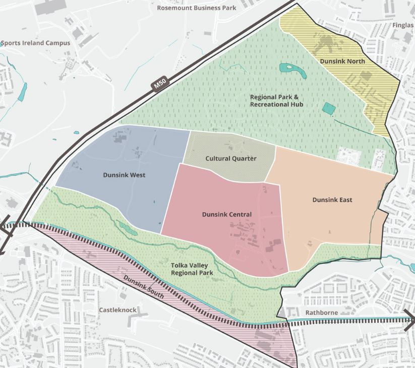
Instead, the Draft Dunsink Urban Area Plan – which sets out where in the 425 hectares of land the council would want homes, roads, parks, and more – envisions a large regional park covering the old landfill.
At the moment, the landfill is a big hill, covered in grass, horses grazing atop it, with views to the east all the way to the Poolbeg smokestacks and the sea.
Others residents just asked for more, better information about the state of the landfill, and the risks it might pose to future development in the area.
"Publish, before the plan is adopted, the current environmental status of the former landfill: its licensing and aftercare position, the extent of capping, and recent landfill gas and leachate monitoring data, in a form ordinary residents can read," wrote Karen Kearney.
Indeed, the Environmental Protection Agency (EPA), which oversees the council's care and monitoring of the old landfill, has published hundreds of reports since 2013 on its website. They look at its impact on groundwater, surface water, and gas emissions, as well as the stability of its slopes, and more.
These are dense, detailed, and complicated. But they show how the council and the EPA have been monitoring and dealing with the landfill's environmental impacts on the area over decades.
The plans
For years, some local councillors have been pushing for faster progress on planning out, and building on, the Dunsink lands.
The council in 2022 published a study looking at the feasibility of developing the lands, which clearly considers the old landfill, but concludes that the Dunsink lands "can accommodate a new urban neighbourhood".
More recently, the central government weighed in, ordering councils across the country – including Fingal – to make more land available for residential development.
In response, Fingal councillors in April rezoned a bunch of sites across the county to make way for up to 2,500 homes.
They also took the Dunsink lands out of their strategic reserve, and committed to come up with a local area plan for developing them – which was to make possible the construction of another 2,500 homes there by 2029.
Later phases should see another 16,000 more homes on top of those, the draft Dunsink plans now show.
This grand vision for the area carves the Dunsink lands up into eight areas, and charts out transport links, different uses, amenities and greenspaces, and rough building heights across them.
Maps in the plan show the bulk of the housing planned for a belt running east-west across the lands.
This belt now hosts the Elmgreen Golf Club, big stretches of open fields, and facilities like the Dunsink Observatory, National Orthopaedic Hospital Cappagh, and Teagasc Ashtown Campus.
To the south of this is belt is the existing Tolka Valley Regional Park, and to the north of the planned development – on the site of the old landfill – the maps show a new 95 hectare regional park.
"Providing a mix of passive and active recreational facilities to serve the new and existing communities including a new recreational hub," it says.
This kind of project is not new. The council is currently turning another old landfill, Balleally, over towards Lusk, into Rogerstown Park.
In its submission to the just-closed public consultation on Fingal's vision for the Dunsink lands, Deirdre French of the EPA said it "supports the repurposing of closed landfills for public amenities, provided that Fingal County Council ensures compliance with all conditions of the waste licence".
The new town next to the old landfill site could eventually fit as many as 18,500 new homes, the plan says. But even once this plan is done and approved, that won't get houses built straightaway.
Council projects will need to be designed, and approved and funded by central government. For lands under private ownership, developers will have to take an interest in the area, find financing, and get planning permission and infrastructure in place – which is all likely to take many years, and happen bit by bit over time.
EPA reports: water
The council's reports to the EPA on the old landfill site look at how it impacts surrounding surface and groundwater, and keep an eye on the gases it is giving off as the waste inside the hill decomposes.
"There is no dedicated stormwater collection system for Dunsink Landfill which is partially capped. Stormwater falling across the facility flows to the local surface water network," according to the council's Annual Environmental Report (AER) for 2025.
Stormwater from the site flows into the Scribblestown Stream and the River Tolka, the report says. On the way, it is monitored, looking at pH and dissolved oxygen, sulphate, boron, and more.
In 2025, the annual surface water monitoring report noted that several things were high in surface water running off the site: suspended solids, ammoniacal nitrogen, and biological oxygen demand.
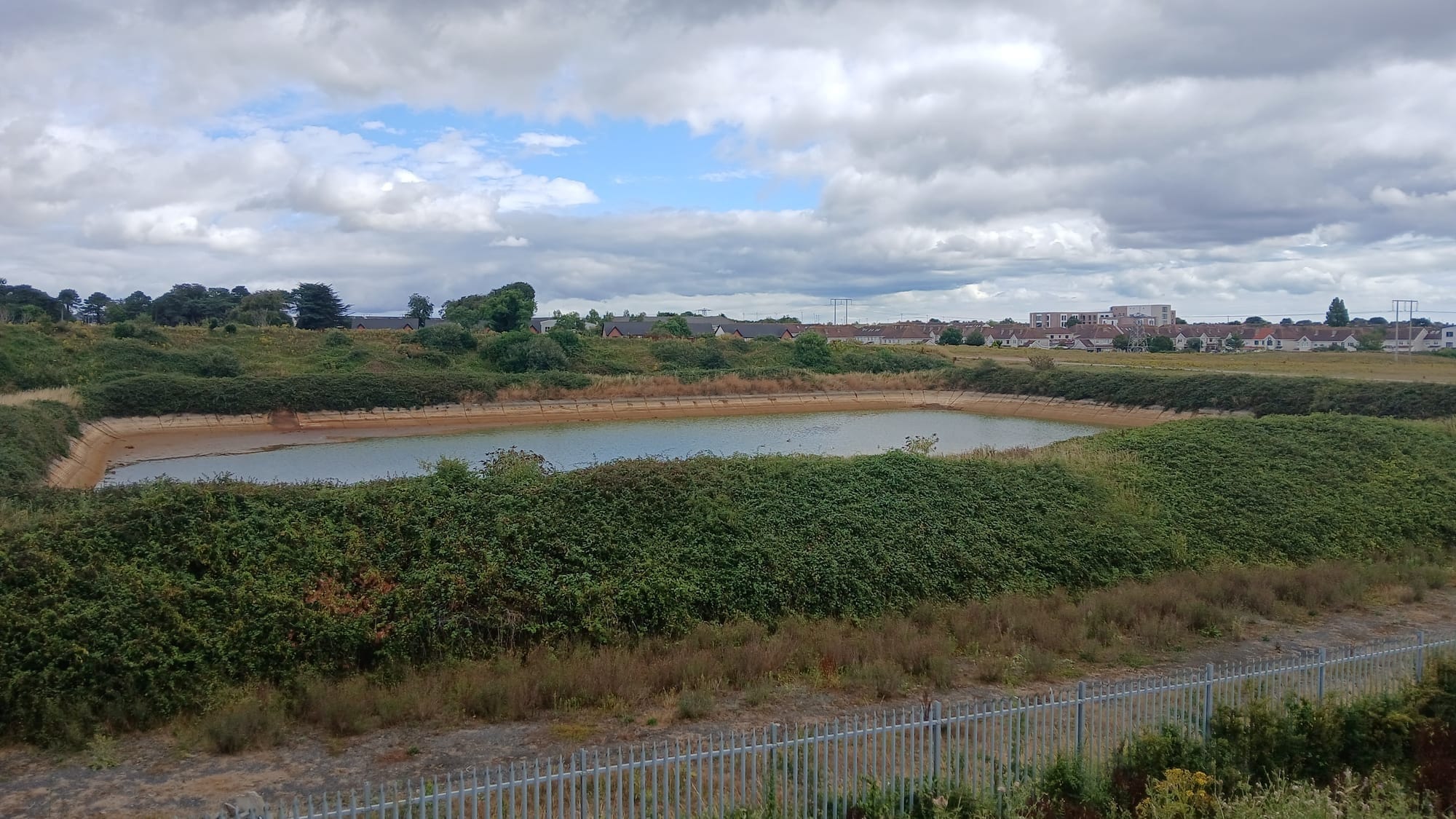
There's also "leachate" that oozes out of the old landfill. There's a leachate lagoon on the site, which looks like a fenced-in pond.
There's a system to monitor how much methane there is dissolved in that leachate, and make sure it's not too high, the 2025 AER says.
"There were no exceedances of the 0.14ug/l licence trigger level for Dissolved Methane at both Leachate Sump and NE Lagoon throughout all monitoring rounds in 2025," the report says.
"Leachate from the leachate lagoon discharges to sewer over two days every week," it says. That flows into the Ringsend Wastewater Treatment Plant, where water is treated and then discharged into the Irish Sea.
In terms of groundwater, the 2025 annual report found that, "Quarterly and annual groundwater monitoring data for the past 7 years indicated that the facility is not impacting the groundwater beneath the facility."
EPA reports: gases
The waste inside the landfill gives off gas as it decomposes.
There's a power plant on the site that uses gas from the landfill to generate electricity that it feeds into the grid.
"6,358 GJs [gigajoules] of renewable energy generated in 2024 and 6,246 GJs of renewable energy was generated in 2025," the Annual Environmental Report (AER) for 2025 says.
Meanwhile, the council is monitoring emissions from the power plants stacks, and gas rising from the landfill site, and keeping an eye on whether gas is seeping through the ground from the site to surrounding areas.
"All parameter results from the Stack Emissions Test were 100% compliant," the 2025 AER said.
There was also a report by a consultant on surface emissions coming off the site into the air in 2025.
"There were twenty zones of surface emissions identified within the landfill facility that exceeded recommended trigger levels," the report found.
This was up from "seven zones of surface emissions identified within the landfill facility that exceeded recommended trigger levels" in 2024, the report says.
There is also the danger of landfill gases travelling underground and surfacing around the site.
The council's 2009 Annual Environmental Report for the site says there were some problems with this back then that they dealt with.
There's a bunch of boreholes in the ground for monitoring levels of gases including methane and carbon dioxide.
In 2004, there were elevated levels of methane at sampling points in the sports grounds north of the closed landfill, and the northern boundary towards Dunsoghly estate, the report says.
"A venting trench was proposed and agreed by the Agency for the remediation of landfill gas migration on the 'sports ground'", the report says. "These works went to public tender and the venting trench was commissioned during Q2 2005."
Flash forward 20 years, in December last year, there were two dozen monitoring wells at the landfill, checked on monthly or quarterly, according to a report that month.
They found lots of "exceedances" – readings high enough to trigger the EPA's attention – of carbon dioxide. "Most of the monitoring locations experienced at least one Carbon Dioxide exceedance," the report said.
On the other hand, "Overall, there was one exceedance of the Methane Trigger level recorded at G45 in 2025," the report says. "No further methane exceedances were recorded at the perimeter wells during monthly/quarterly monitoring in 2025."
Of course, that one exceedance was big. The "trigger limit" was 1 percent and the level at G45 in February 2025 was 7.2 percent the report says.
Methane's especially tricky, of course, because it's flammable. That leachate lagoon, where the amount of methane dissolved in the ooze that comes out of the landfill?
There's a fence around it and a sign saying "Danger: Explosive Atmosphere". The 2025 leachate report, though, says "There were no exceedances at NE [north east] Lagoon for any parameter throughout 2025."
In the most recent available report, last month, the council notified the EPA about a big spike in methane at the lagoon. "Result for dissolved methane at both locations are very high and have never been detected at these levels before."
But it's apparently not clear if that's a real spike, or something wrong with the sampling. They decided to check the equipment, and techniques used for sampling, and get another sample.
In response to a query about the sign around the lagoon, an EPA spokesperson said that "Warning signs may be used on landfill sites to identify areas where landfill gas may be present and where appropriate safety precautions are required. The presence of such signage does not in itself indicate a risk to the wider public."
"While the EPA is aware of plans to develop the site as a park and recreational amenity, no detailed proposals have been received from Fingal County Council," the spokesperson said. "Any future proposals requiring EPA consideration would be assessed to ensure that potential risks to human health and the environment, including those associated with landfill gas, are appropriately addressed."
The council has not responded to a query sent Tuesday asking for its response to the suggestion that building a regional park on this site might be risky.
Protecting nearby homes
With the danger of gases migrating off the site to surrounding areas in mind, when Greenwich Project Holdings in 2017 applied for permission to add 52 homes on to the Dunsoghly estate in Finglas, just north-east of the landfill, the council asked for a risk assessment.
"The presence of the Cappagh stream (and the trench excavated by Fingal County Council) located between the County Council lands and the proposed site will act as a barrier to gas movement towards the site," that risk assessment said when it was completed.
"Nevertheless, it is proposed that mitigation measures be implemented to negate any potential risks and these include the installation of a constructed floor slab with gas resistant membrane and a passively ventilated underfloor sub-space in all residential structures," it said.
All the underground services and utilities, like sewers, gas mains, stormwater drains, and water pipes should be adequately vented so they don't become pathways for gas to move underground, it said.
And fences should be put up between the housing estate and the landfill site, "to restrict infrastructure associated with the landfill including the leachate lagoon and the gas monitoring boreholes".
Together, this should be "more than adequate to ensure no impact from landfill gases at the proposed development site", the report said.
UPDATE: This article was updated at 15.08 on 5 August 2026 to include comments from an EPA spokesperson.
UPDATE: This article was updated at 10.16 on 6 August to include a line saying the council has not responded to a query for this story that was sent on 4 August.
"There is just a ridiculous overconcentration of short-term accommodation," in the Blackpitts and Newmarket Square area, says Sinn Féin Councillor Ciaran Ó Meachair.
A false alarm from the Barclay Crop Protection plant near Mulhuddart in July confused some locals, who didn't know what it was, what it meant, or how to get more information.