Some tenants had been disconnecting window restrictors put in to keep people from falling out windows, which are required under building regulations, an email from the building manager said.
Consolidating operations into one main hub would be the dream, says Amy Carey, CEO of Solas Project, but they don't yet know what doing up the vacant building on Cork Street would cost.
The shift to a lower-carbon heating system would reduce big-picture costs, like, global costs, societal costs. But how would it affect customers' bills?
Along the narrow Lower Road, west of Chapelizod, west of the Angler’s Rest, there are a series of homes set into steep, wooded hillside, overlooking the river.
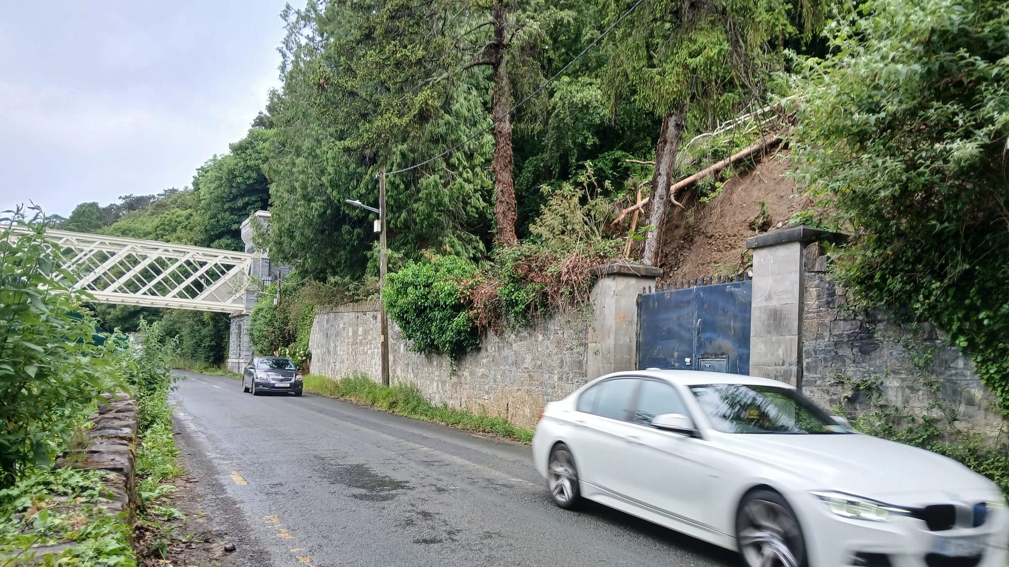
On 13 February, with a sound some local residents thought was thunder, part of the hill slipped down towards the Lower Road in Strawberry Beds, near where the Guinness bridge spans the Liffey.
It had been a rainy winter, with Storm Claudia in November, Storm Bram in December, Storm Chandra in late January and more flooding in Dublin in early February. The ground was saturated.
The slip had started up near Ardmaroon House, a private house at the top of the hill, and then slid down across steep, tree-covered land owned by another person.
The dirt and trees and brush and rocks then settled on council-owned land behind a stone wall and blue metal fence. The council closed the road for about a week, to clean up, and ensure everything was safe.
At a meeting of the council’s Blanchardstown area committee on Thursday, Fine Gael Councillor Ted Leddy tabled a motion to ask the council to do research into, and issue a report on, “the safety and integrity of the land on the northern slopes of Liffey Valley”.
“The residents living there and people that use that road need to know that it’s safe,” Leddy said at the meeting.
Some areas above the Lower Road have “dramatically changed” in recent years, Leddy said.
“You look at the Castleknock Hotel, the Castleknock GAA club, Diswellstown Manor, the redevelopment of Porterstown Park – there’s been a huge amount of activity there, and for all we know that has had some sort of an impact on drainage,” he said.
Yes, said local resident Leonard Skelly, sat by the brown river late Tuesday morning as it rushed east under blue skies and sunshine, towards the sea, all the development in the area is definitely affecting the way the water moves down into and through this valley.
“There has always been flooding in Strawberry Beds, and people who lived here have lived with it, and are in touch with the land – developers are not,” Skelly said. “The farmland has all been bought up and there’s nowhere for the water to seep away.”
The problem is set to get worse, Skelly says, if South Dublin County Council rezones lands upstream near Lucan at St Edmundsbury, as it has proposed, so that 540-ish new homes could be built there. “That’s going to affect us all downriver,” he says.
At the meeting
At the meeting on Thursday, Aontú’s Ellen Troy, Fianna Fáil’s J.K. Onwumereh, and Labour’s John Walsh all indicated their support for Leddy’s motion.
“That side, the steep slope, it’s really steep,” said Troy. “I think it’s a serious issue.”
“That general area really really looks troubling in terms of the topography and the possibility of landslide,” Onwumereh said.
In response to Leddy’s motion, Hugh James, a senior executive engineer at the council, wrote up a report, explaining the landslide and road closure. At the meeting, James said he didn’t have much to add.
“The weather was the major cause of that, which was sort of unprecedented,” James said.
The council got some consultants in to look at the situation, James said. “We have received a report from the consultant but we have had queries and we have gone back to them for clarifications and further information and also have requested a second inspection there following the clearing out of the debris material,” he said.
That’s great that the council got a consultant in to look at the issue, Leddy said. When the report’s done, he’d like to see it, he said.
There’s a Special Amenity Area Order (SAAO) on the area, he said “which is the highest level of protection, so if that requires extra protection, extra care and attention”.
Said Walsh, the Labour councillor: “I would also like to see the consultants’ report.”
Actually, the council is going to be talking with the private landowners involved before releasing any report to councillors or the public, said Fingal senior executive officer Vanessa Carey, at the meeting on Thursday.
The landslide began near the driveway to Ardmaroon House. Past planning documents say Marian Dalton in 2017 got permission to build a one-storey extension to that house, and was refused permission to also convert a garage into “living accommodation”.
The landslide then crashed downhill through undeveloped, forested land that, from photos and maps, appears to be owned – according to property records – by Alan Adams, of Castleknock.
“I think we want to deal with the third parties first,” said Carey, the council senior executive officer.
Mark Sinnott, chair of the Strawberry Beds Residents Association, said on Tuesday that they “look forward to seeing the findings when available”.
“The Strawberry Beds is a unique area of significant environmental, landscape and heritage value, and any measures that improve understanding of potential risks and help protect the area for residents, visitors and future generations are to be welcomed,” Sinnott said.
The site of the landslide, on Tuesday. Photo by Sam Tranum.
Some tenants had been disconnecting window restrictors put in to keep people from falling out windows, which are required under building regulations, an email from the building manager said.
The shift to a lower-carbon heating system would reduce big-picture costs, like, global costs, societal costs. But how would it affect customers' bills?